
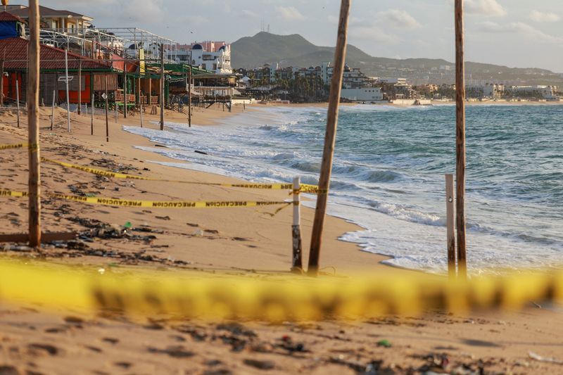
(Mexico City, 28 September 2026) — As Hurricane Polo bore down on Mexico’s Pacific coastline, the true human cost of the Atlantic hurricane season’s escalating ferocity was already being felt hundreds of miles from where the storm would eventually make landfall. Beaches that would normally be packed with tourists lay empty behind yellow police tape. Ports sat silent. Schools closed their doors. And in coastal communities stretching the length of Baja California Sur, families braced for what forecasters warned could be one of the most destructive storms to strike the region in years.
Polo, a Category 3 hurricane tracking northward along Mexico’s Pacific coast, was confirmed to be on course for landfall on the Baja California Sur shoreline on Monday night, according to the US National Hurricane Center. The storm has placed an entire stretch of one of Mexico’s most visited resort corridors directly in harm’s way — and the window to prepare is closing fast.
The Long-Standing Vulnerability of Baja California Sur’s Coastal Communities Continues to Trouble Residents and Tourists Alike
For the communities hugging the southern tip of the Baja California peninsula, the threat of Pacific hurricane season is not a new anxiety. Every year, as warm sea-surface temperatures peak in the eastern Pacific, coastal cities like Cabo San Lucas and San Jose del Cabo find themselves in the potential path of storms that develop rapidly and intensify with little warning.
This season, that vulnerability has been laid bare once again. At Medano Beach in Cabo San Lucas — one of the most photographed stretches of sand in all of Mexico — yellow warning tapes fluttered in the gusting wind on Sunday, September 27, marking the closure of a beach that typically draws thousands of visitors each week. In San Jose del Cabo, authorities moved swiftly to restrict access to the shoreline as Polo churned up large, dangerous waves and powerful surf capable of pulling swimmers and bystanders into the sea.
Across the region, the warning signs were unambiguous: port closures disrupted maritime commerce and passenger ferry services, school cancellations kept children home, and evacuation orders pushed residents inland away from low-lying flood zones. These are not precautions taken lightly in communities whose economies depend on tourism, and whose geography leaves little natural buffer against a major Atlantic or Pacific storm.
Why Hurricane Polo’s Threat Is So Hard to Contain: The Underlying Reasons Are More Complex Than Expected
In fact, the challenge of managing Hurricane Polo goes far beyond the storm’s raw wind speed. As of 11:00 a.m. EDT on Sunday, September 27, Polo was positioned approximately 200 miles off the Baja California coast, moving north-northwest at 12 mph with sustained winds of 125 mph — figures that place it squarely within Category 3 classification on the Saffir-Simpson scale.
At its core, the danger presented by Polo stems from a combination of factors that compound one another in dangerous ways. Even as private forecaster AccuWeather projected a gradual weakening of the storm before landfall — potentially dropping it to Category 1 intensity — the organisation cautioned that even a weakened Polo carries sufficient energy to topple trees, bring down power lines, and inflict measurable structural damage to buildings along its path.
The secondary hazard — rainfall — may ultimately prove more destructive than the winds themselves. The US National Hurricane Center forecast that Polo will deposit between 4 and 8 inches (10 to 20 centimetres) of rainfall across Baja California. That volume of precipitation in a condensed timeframe raises the risk of life-threatening flash flooding and mudslides in terrain where drainage infrastructure was not designed to handle rapid, large-scale runoff. Once Polo crosses the Gulf of California, it is expected to carry those rainfall totals inland into the northern Mexican states of Sonora and Chihuahua — extending the disaster footprint well beyond the coast.
Facing a Major Pacific Hurricane, the Limitations of Existing Emergency Responses Remain Evident
Mexico’s civil protection authorities have activated standard emergency protocols in response to Polo’s approach — a well-rehearsed sequence of beach closures, port shutdowns, evacuation advisories, and school cancellations that forms the backbone of the country’s hurricane preparedness framework. These measures are familiar and, when implemented early, demonstrably effective at reducing casualties.
Nevertheless, the limitations of these protocols become clear under sustained or severe storm conditions. Evacuation compliance in tourist-heavy resort cities depends heavily on the speed and reach of public communication, particularly for the large number of international visitors who may not be monitoring local Spanish-language emergency broadcasts. Infrastructure resilience remains uneven across the region, with older residential construction in lower-income neighbourhoods especially susceptible to wind and flood damage. And the extended inland trajectory of storms like Polo — crossing into Sonora and Chihuahua after making landfall — frequently means that inland communities with fewer emergency resources bear a disproportionate share of the post-storm burden.
Frequently Asked Questions About Hurricane Polo
What category is Hurricane Polo as it approaches Mexico? Hurricane Polo is classified as a Category 3 hurricane as it approaches Mexico’s Pacific coast, with sustained winds of 125 mph recorded as of 11:00 a.m. EDT on Sunday, September 27, 2026.
When is Hurricane Polo expected to make landfall in Mexico? Hurricane Polo is forecast to make landfall on the Pacific coast of Baja California Sur on Monday night, September 28, 2026, according to the US National Hurricane Center.
How much rainfall will Hurricane Polo bring to Baja California? The US National Hurricane Center projects that Hurricane Polo will deliver between 4 and 8 inches (10 to 20 centimetres) of rainfall across Baja California, creating a significant risk of flash flooding and mudslides.
Will Hurricane Polo weaken before it reaches land? Private forecaster AccuWeather projects that Hurricane Polo will gradually weaken before making landfall, potentially reaching Category 1 intensity at the point of landfall. Even at Category 1 strength, the storm carries sufficient force to down trees, knock out power lines, and cause structural damage.
Which areas of Mexico are under threat from Hurricane Polo beyond the coast? After making landfall on the Baja California Sur coast, Hurricane Polo is forecast to cross the Gulf of California and move into the northern Mexican states of Sonora and Chihuahua, extending flood and mudslide risks well inland.
What emergency measures have Mexican authorities taken ahead of Hurricane Polo’s landfall? Mexican authorities have implemented beach access restrictions, port closures, school cancellations, and evacuation orders along the Pacific coast. In San Jose del Cabo, beach access was specifically restricted due to dangerous surf conditions generated by the approaching storm.
How fast is Hurricane Polo moving and in which direction? As of 11:00 a.m. EDT on Sunday, September 27, 2026, Hurricane Polo was moving north-northwest at 12 mph, located approximately 200 miles off the Baja California coastline.
As Hurricane Polo closes in on one of Mexico’s most economically significant coastal corridors, the storm represents a concentrated test of the country’s emergency preparedness infrastructure and the resilience of communities long accustomed to living within reach of the eastern Pacific hurricane belt. The coming hours will determine how much of the storm’s destructive potential translates into lasting damage across both the Baja California shoreline and the inland states in its projected path.
Reporting by Emily Green; Editing by Nia Williams. Source: Reuters.